Home < services < GIS Driven Software Developmentt
SCOPE OF WORK
GIS Driven Software Developmentt
Comprehensive domain knowledge including real world domain experience of over THREE DECADES in Pipelines, Property and Land Records, Highway, Irrigation and Water Resources, Public Health, Geotechnical, Surveying and Mapping, and associated engineering domains sets it apart from other Geospatial and software companies who have no in-house domain experience and knowledge.
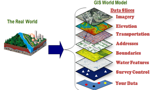
GIS AND SOFTWARE DEVELOPMENT
SECON has developed advanced GIS and Geo-spatial applications using multiple GIS platforms like:
- ESRI – ArcGIS Server, ArcGIS Desktop and Mobile
- Autodesk AutoCAD Map
- Bentley Microstation
- MapInfo MapXtreme
- Google Maps, Bing Maps
- Open Source Solutions like Map Guide, QGIS, Map Server, Open Street Maps
We deliver various software solutions using the following technologies:
- Microsoft .NET
- Android and IOS Mobile platforms
We also undertake project management and strategic consulting with professional services.
- ROUTE OPTIMIZATION AND CORRIDOR PLANNING
- Using the advanced GIS tools, developed in-house, we provide optimized route and corridor planning to our customers in Canals, Highways and Cross Country long distance pipelines.
- Extensive use of satellite imagery for data capture, updation, validation of land use and latest developments.
- Other tools used include DGPS, Total Stations and in-house software for presentation of deliverables like alignment sheets, crossing drawings, stratification, ground profile, property information etc. that enable SECON to execute major projects in Pipelines, Irrigation and Water Management, in record time.